

Resources

Classroom drone essentials - a starting point for geoscience
Making teaching with technology easy, and engaging children with interactive hands-on learning.
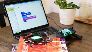
Co Drone EDU - teaching made easy with drones.
A small but mighty little drone, easy set-up, responsive and straight forward to operate, for both teachers and students.

Satellite images in class - see things that others can't
Satellite images are not only cool to look at, but they can also be a treasure trove of information for leaners of all ages.

Use Landsat images to write your name, it's great fun!
Looking for a easy way to introduce mapping and landform features? Take a look at your name in Landsat satellite imagery

Spatial resolution -what is it, and what's great about drones?
Curious to know why drones have the upper hand when obtaining aerial imagery? Dr Karen Joyce at GeoNadir explains ....................
Understanding map features and how to read them
The Classroom Drone Essentials Program introduces the class to basic mapping features. They even get to design their own!

Using trigonometry to calculate pixel size in aerial imagery
Have you used trigonometry other than in your school maths class? Take a watch Karen Joyce at She Maps explains how we can determine pixel size from our aerial equipment height.

Raindrop to the Sea! Great for river systems learning.
This useful platform lets you trace what happens to a drop of rain when it falls to the ground. A great introduction to river systems, and river flow.

Humanitarian OpenStreet Map
Join the army of volunteers supporting communities all over the world. Learn to map the basics with the HOT tasking manager experts and join a mapathon event.

Glacial monitoring - how drones can help.
Drones help scientists study glaciers up close by capturing detailed images and data that reveal how they are melting and changing with climate.

Geospatial science is everywhere - take a look at the diverse roles involved.
Geospatial science is everywhere, and so are its careers. The careers booklet highlights the exciting, diverse and future-focused roles across mapping, technology, environment and infrastructure.